I am exhausted! Today, after months of wanting to do this, I went to hike Mt. Tom in Holyoke with my brother Matt. It couldn't have been a more gorgeous day for trekking approximately 1202 ft. in elevation through 6.7 miles of trail, the sun shining and the temperature just warm enough without being too humid.
The trails were so beautiful! This is what I wrote in my journal about it:
22 July 2012
The trail was littered with shards of rock, as if God had taken pottery and smashed and shattered it against the face of the mountain. The trees, illuminated with the perfect sky's sunlight, let a green glow rain down through its leaves. It was a serene paradise.
 |
| Beginning my 6.7 mile hike to the peak of Mt. Tom!! |
The trail itself, the Metacomet-Menadnock Trail, was not difficult all together. I'll admit, I got a little nervous when we approached a very steep climb early on in the hike; a set of rock stairs that might as well have been perfectly vertical. However, the trail was a merciful one; while there were a series of steep rock climbing sequences (which I happen to love), there were also several downhill portions. Now, if you plan on hiking this trail, the downhill portions might be misleading-- I know I got confused, because I thought, "Hey, I'm hiking a mountain, aren't we supposed to be going up?!" But, thanks to the many landmarks on the trail, we were able to keep track of where we were.
 |
| The first series of steep climbing... not looking too ready for it yet! |
 |
| More steep passageways-- now I'm up for it! |
One of the best parts of the trail were the countless vantage points with stunning scenic views of Holyoke, Amherst, and other points of the valley. I could make out UMass Amherst, farms, and the Connecticut River from some of the scenic points:
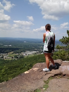 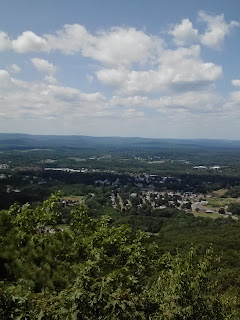  |
| Enjoying the breath-taking views along the way! |
 |
| We saw some falcons circling some of the vantage points |
 |
| Matt was particularly fascinated by this tiny lizard we found. Ew. |
Another great part of the trail, as I mentioned earlier, were the land marks that helped you figure out how close you were to the peak and in what general direction you should be headed. You see, the Mt. Tom experience is not the kind that will get you totally immersed in nature like you're some Mt. Everest explorer (although I like to pretend that is the case). Mt. Tom is the broadcasting site for 3 Springfield-Holyoke television stations, so there are several antennae and towers marked on the map to be your guide. There is also the UMass Amherst windmill that is a key point on the trail. In fact, the peak of the trail is among a series of telephone wires, broadcasting towers, and even a star-shaped light display.
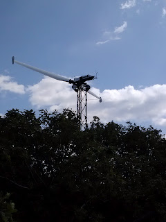  |
| The UMass Amherst Windmill, and me at the peak of Mt. Tom with the star light display! What a view! |
After reaching the peak, we decided to hike down the other side of the mountain rather than turning around. It all went downhill from there (if you'll pardon that disgusting pun. I can't help myself!) We got out of the woods and wound up on the side of Route 141 with no idea where we were. Still having the notion that I was a great explorer, I was certain we ought to head East on Route 141 after one look at the map. However, Matt caught on after almost 2 miles of walking the wrong way that we should have taken a left. But, what is life without a few things going wrong to keep things interesting anyways?
 |
| This is what utterly and hopelessly lost looks like |
After 4 hours of walking, be it hiking gloriously through nature trails or wandering mindlessly along the side of major roads, the trip to Mt. Tom was a great experience! I'm hoping to go again in the fall when the trees are in full autumn color-- it will be like a whole new hike!

No comments:
Post a Comment